Umang Sisodia • • 5 min read • 1 view

Cyclone Murasu Threatens Andhra Coast: Forecast, Impact & Long‑Term Implications
Listen to Article
Select a voice and press play
Cyclone Murasu Threatens Andhra Coast: Forecast, Impact & Long‑Term Implications

Key Takeaways

  • Cyclone Murasu is projected to make landfall on Andhra Pradesh's coast around November 3, just weeks after Cyclone Arnab.
  • The storm is expected to bring winds up to 120 km/h, heavy rainfall, and a storm surge of 2‑3 meters, threatening coastal districts and inland agriculture.
  • Emergency agencies are on high alert; early evacuations, pre‑positioned relief kits, and robust communication networks are critical.
  • Climate‑change‑driven sea‑surface warming is intensifying cyclone frequency, urging a rethink of India’s coastal resilience strategies.

India’s western Bay of Bengal has once again become a hotbed of tropical activity. Within a fortnight of Cyclone Arnab weakening over the sea, the India Meteorological Department (IMD) has issued a severe cyclonic storm warning for a new system—Cyclone Murasu—that is tracking westward towards the Andhra coast.

The Meteorological Backdrop

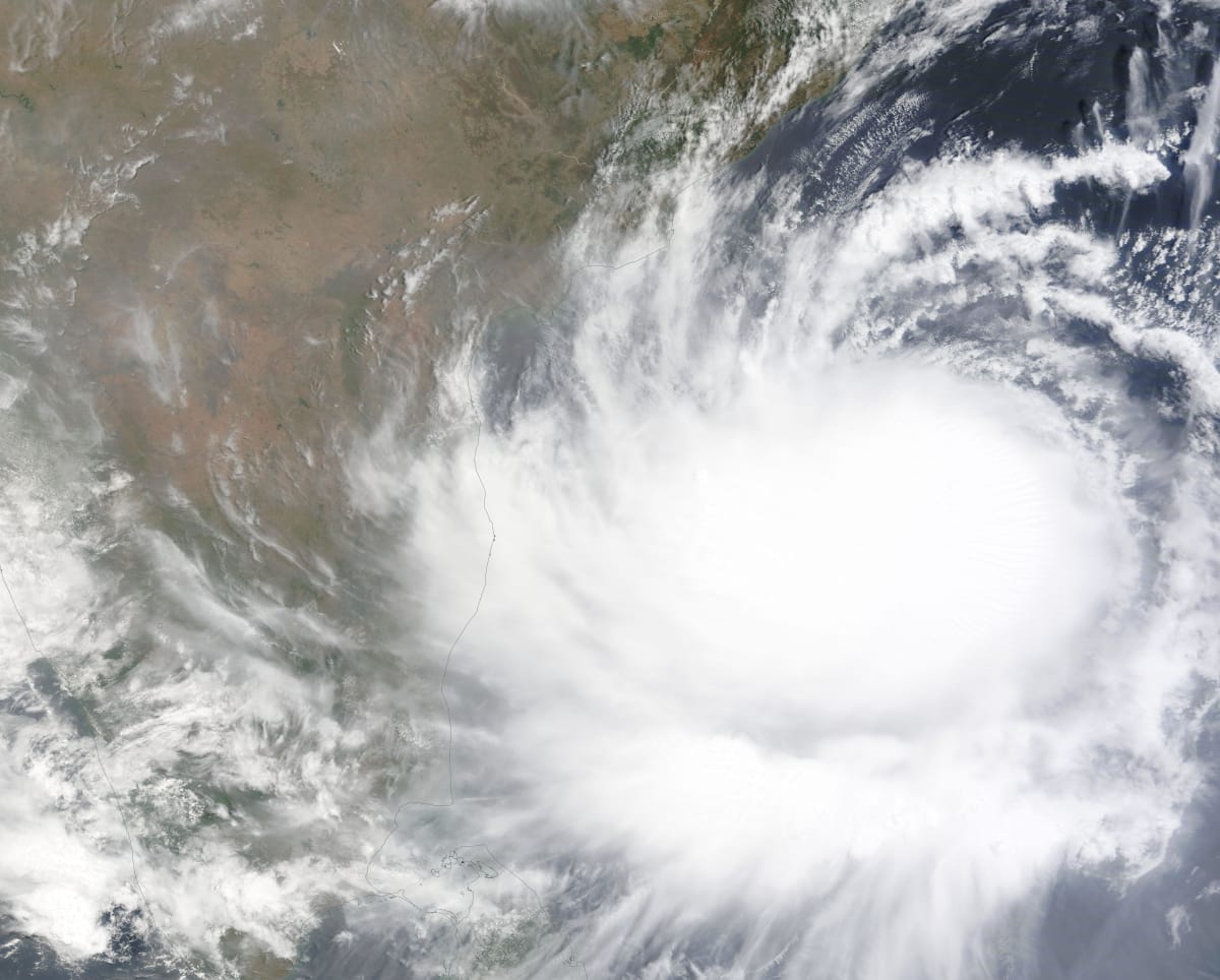
The IMD’s latest advisory (issued on 30 Oct) places Murasu at 84 km/h sustained winds, with a central pressure of 996 hPa. Satellite imagery shows a classic well‑defined eye forming, a sign that the system is rapidly organizing. Sea‑surface temperatures (SST) in the Bay of Bengal hover around 30‑31 °C, providing ample thermal energy to fuel further intensification.

"The oceanic heat content in the Bay of Bengal is at a multi‑year high, creating a perfect incubator for cyclones," – Dr. Ramesh Kumar, senior climatologist, Indian Institute of Tropical Meteorology.

Cyclone Murasu: Track and Forecast

The projected path, derived from the IMD’s Cyclone Phase Space model and corroborated by the Joint Typhoon Warning Center (JTWC), suggests a west‑northwestward trajectory, making landfall near Kakinada or Rajahmundry districts between 02:00‑06:00 IST on Nov 3. The storm is expected to weaken as it crosses the Eastern Ghats, but not before dumping 300‑400 mm of rain over a 72‑hour window.
Andhra Pradesh coastal village evacuation Andhra Pradesh coastal village evacuation

Potential Impact on Andhra Pradesh

1. Coastal Communities

  • Storm surge: 2‑3 meters could inundate low‑lying habitations, especially in East Godavari and West Godavari districts.
  • Housing damage: Over 15,000 structures are classified as vulnerable in the IMD’s risk matrix.

2. Agriculture & Livelihoods

  • Paddy fields: The monsoon‑kharif transition is at a critical stage; excess water may ruin an estimated 1.2 lakh hectares of standing crops.
  • Aquaculture: Shrimp farms along the coast could suffer losses exceeding ₹1,200 crore if salinity intrusion occurs.

3. Infrastructure & Power

  • Road networks: The National Highway 16 corridor, a lifeline for freight, is at risk of flooding and landslides.
  • Power outages: Preliminary assessments by AP Power Generation Corp. indicate potential disruption for 2‑3 million consumers.

Government & Disaster Management Response

The National Disaster Management Authority (NDMA) has pre‑emptively activated Level‑2 protocols:

  • Evacuation centers: Over 50,000 temporary shelters have been readied across vulnerable taluks.
  • Relief kits: Pre‑positioned food, clean water, and medical supplies sufficient for 30,000 families.
  • Communication: The Ministry of Home Affairs has set up a dedicated helpline (1070) and is leveraging cell‑broadcast alerts to disseminate real‑time warnings.

State officials in Andhra Pradesh, led by Chief Minister Y. S. Jagan Mohan Reddy, have urged residents to stay indoors, secure loose objects, and follow instructions from local authorities. The state’s Coastal Disaster Management Authority (CDMA) is conducting drills in high‑risk zones to test rapid response capabilities.

Historical Context: Cyclones in the Bay of Bengal

The Bay of Bengal has a notorious record of producing intense cyclones—the 1999 Odisha super‑cyclone (Category 5) and Cyclone Fani (2019) being stark reminders. Since 2000, the frequency of Severe Cyclonic Storms (SCS) in the region has risen from an average of 3 per year to 5‑6 per year, a trend linked to climate change and anthropogenic warming.

Climate Change – The Underlying Driver

Recent research from the Intergovernmental Panel on Climate Change (IPCC) highlights that a +1.5 °C rise in global temperature can increase the probability of Category 4‑5 cyclones by up to 30 % in the Indian Ocean. Warmer SSTs, reduced vertical wind shear, and higher atmospheric moisture content collectively create a more conducive environment for rapid cyclogenesis, as seen with Murasu.

What Residents Can Do Now

  • Stay informed: Subscribe to IMD alerts via SMS or the India Meteorological app.
  • Secure property: Reinforce doors, windows, and roofs; store important documents in waterproof containers.
  • Prepare emergency kits: Include flashlights, batteries, first‑aid supplies, and at least 3 liters of drinking water per person per day.
  • Follow evacuation orders: Do not attempt to return home until authorities declare it safe.

Editorial Analysis & Future Outlook

Cyclone Murasu underscores a new normal for India’s eastern seaboard. While emergency services have markedly improved since the 1999 Odisha disaster—evidenced by faster evacuation times and better pre‑positioned supplies—the scale of climate‑induced risk demands a strategic overhaul.

Strengthening Coastal Resilience

Long‑term mitigation must focus on nature‑based solutions: mangrove restoration, sand‑dune reinforcement, and the creation of buffer zones that absorb storm surges. The National Coastal Zone Management Authority (NCZMA) should fast‑track its “Coastal Green Belt” initiative, integrating community‑led stewardship with scientific monitoring.

Policy Implications

  • Urban planning: Enforce stricter building codes for coastal municipalities, mandating cyclone‑resistant designs.
  • Insurance: Expand affordable crop and property insurance schemes to cushion farmers against repeated losses.
  • Data integration: Leverage AI‑driven predictive models that fuse satellite data, oceanic buoys, and ground observations for more precise track forecasts.

The Road Ahead

If the frequency of back‑to‑back cyclones continues, the economic cost could eclipse ₹10,000 crore annually for Andhra Pradesh alone, eroding development gains. However, proactive adaptation—combining robust disaster management, climate‑smart agriculture, and infrastructure retrofitting—can transform vulnerability into resilience.

In sum, Cyclone Murasu is more than a weather event; it is a litmus test for India’s capacity to confront a warming world. The actions taken today will shape the safety and prosperity of millions along the Bay of Bengal for decades to come.


Original Reporting & Source: India Today Top Stories

Discussion (0)

Sign in to join the discussion.

No comments yet. Be the first to start the conversation!

| |

Cyclone Murasu Threatens Andhra Coast: Forecast, Impact & Long‑Term Implications

By Umang Sisodia • 5 min read • 1 view

Key Takeaways

  • Cyclone Murasu is projected to make landfall on Andhra Pradesh's coast around November 3, just weeks after Cyclone Arnab.
  • The storm is expected to bring winds up to 120 km/h, heavy rainfall, and a storm surge of 2‑3 meters, threatening coastal districts and inland agriculture.
  • Emergency agencies are on high alert; early evacuations, pre‑positioned relief kits, and robust communication networks are critical.
  • Climate‑change‑driven sea‑surface warming is intensifying cyclone frequency, urging a rethink of India’s coastal resilience strategies.

India’s western Bay of Bengal has once again become a hotbed of tropical activity. Within a fortnight of Cyclone Arnab weakening over the sea, the India Meteorological Department (IMD) has issued a severe cyclonic storm warning for a new system—Cyclone Murasu—that is tracking westward towards the Andhra coast.

The Meteorological Backdrop

The IMD’s latest advisory (issued on 30 Oct) places Murasu at 84 km/h sustained winds, with a central pressure of 996 hPa. Satellite imagery shows a classic well‑defined eye forming, a sign that the system is rapidly organizing. Sea‑surface temperatures (SST) in the Bay of Bengal hover around 30‑31 °C, providing ample thermal energy to fuel further intensification.

"The oceanic heat content in the Bay of Bengal is at a multi‑year high, creating a perfect incubator for cyclones," – Dr. Ramesh Kumar, senior climatologist, Indian Institute of Tropical Meteorology.

Cyclone Murasu: Track and Forecast

The projected path, derived from the IMD’s Cyclone Phase Space model and corroborated by the Joint Typhoon Warning Center (JTWC), suggests a west‑northwestward trajectory, making landfall near Kakinada or Rajahmundry districts between 02:00‑06:00 IST on Nov 3. The storm is expected to weaken as it crosses the Eastern Ghats, but not before dumping 300‑400 mm of rain over a 72‑hour window.

Andhra Pradesh coastal village evacuation Andhra Pradesh coastal village evacuation

Potential Impact on Andhra Pradesh

1. Coastal Communities

  • Storm surge: 2‑3 meters could inundate low‑lying habitations, especially in East Godavari and West Godavari districts.
  • Housing damage: Over 15,000 structures are classified as vulnerable in the IMD’s risk matrix.

2. Agriculture & Livelihoods

  • Paddy fields: The monsoon‑kharif transition is at a critical stage; excess water may ruin an estimated 1.2 lakh hectares of standing crops.
  • Aquaculture: Shrimp farms along the coast could suffer losses exceeding ₹1,200 crore if salinity intrusion occurs.

3. Infrastructure & Power

  • Road networks: The National Highway 16 corridor, a lifeline for freight, is at risk of flooding and landslides.
  • Power outages: Preliminary assessments by AP Power Generation Corp. indicate potential disruption for 2‑3 million consumers.

Government & Disaster Management Response

The National Disaster Management Authority (NDMA) has pre‑emptively activated Level‑2 protocols:

  • Evacuation centers: Over 50,000 temporary shelters have been readied across vulnerable taluks.
  • Relief kits: Pre‑positioned food, clean water, and medical supplies sufficient for 30,000 families.
  • Communication: The Ministry of Home Affairs has set up a dedicated helpline (1070) and is leveraging cell‑broadcast alerts to disseminate real‑time warnings.

State officials in Andhra Pradesh, led by Chief Minister Y. S. Jagan Mohan Reddy, have urged residents to stay indoors, secure loose objects, and follow instructions from local authorities. The state’s Coastal Disaster Management Authority (CDMA) is conducting drills in high‑risk zones to test rapid response capabilities.

Historical Context: Cyclones in the Bay of Bengal

The Bay of Bengal has a notorious record of producing intense cyclones—the 1999 Odisha super‑cyclone (Category 5) and Cyclone Fani (2019) being stark reminders. Since 2000, the frequency of Severe Cyclonic Storms (SCS) in the region has risen from an average of 3 per year to 5‑6 per year, a trend linked to climate change and anthropogenic warming.

Climate Change – The Underlying Driver

Recent research from the Intergovernmental Panel on Climate Change (IPCC) highlights that a +1.5 °C rise in global temperature can increase the probability of Category 4‑5 cyclones by up to 30 % in the Indian Ocean. Warmer SSTs, reduced vertical wind shear, and higher atmospheric moisture content collectively create a more conducive environment for rapid cyclogenesis, as seen with Murasu.

What Residents Can Do Now

  • Stay informed: Subscribe to IMD alerts via SMS or the India Meteorological app.
  • Secure property: Reinforce doors, windows, and roofs; store important documents in waterproof containers.
  • Prepare emergency kits: Include flashlights, batteries, first‑aid supplies, and at least 3 liters of drinking water per person per day.
  • Follow evacuation orders: Do not attempt to return home until authorities declare it safe.

Editorial Analysis & Future Outlook

Cyclone Murasu underscores a new normal for India’s eastern seaboard. While emergency services have markedly improved since the 1999 Odisha disaster—evidenced by faster evacuation times and better pre‑positioned supplies—the scale of climate‑induced risk demands a strategic overhaul.

Strengthening Coastal Resilience

Long‑term mitigation must focus on nature‑based solutions: mangrove restoration, sand‑dune reinforcement, and the creation of buffer zones that absorb storm surges. The National Coastal Zone Management Authority (NCZMA) should fast‑track its “Coastal Green Belt” initiative, integrating community‑led stewardship with scientific monitoring.

Policy Implications

  • Urban planning: Enforce stricter building codes for coastal municipalities, mandating cyclone‑resistant designs.
  • Insurance: Expand affordable crop and property insurance schemes to cushion farmers against repeated losses.
  • Data integration: Leverage AI‑driven predictive models that fuse satellite data, oceanic buoys, and ground observations for more precise track forecasts.

The Road Ahead

If the frequency of back‑to‑back cyclones continues, the economic cost could eclipse ₹10,000 crore annually for Andhra Pradesh alone, eroding development gains. However, proactive adaptation—combining robust disaster management, climate‑smart agriculture, and infrastructure retrofitting—can transform vulnerability into resilience.

In sum, Cyclone Murasu is more than a weather event; it is a litmus test for India’s capacity to confront a warming world. The actions taken today will shape the safety and prosperity of millions along the Bay of Bengal for decades to come.


Original Reporting & Source: India Today Top Stories